 Slovenski INSPIRE metapodatkovni sistem
Keyword
Podobe/Osnovne karte/Pokrovnost
24 record(s)
Type of resources
Categories
INSPIRE themes
Keywords
Formats
Representation types
Scale
Resolution
-
Gre za bazo pokrovnosti tal za leto 2012. Baza podatkov CLC 2012 predstavlja pokrovnost tal za leto 2012. CLC 2012 je kombinacija revidirane baze za leto 2006 in baze sprememb med letoma 2006 in 2012. V Sloveniji je 34 razredov od 44 kot jih pozna CORINE. Najpogostejši tip pokrovnosti so gozdovi, ki predstavljajo več kot 50 % površja. Podatki so v vektorski prostorski bazi. Karta predstavlja realno stanje, ki ga je zaznal satelit.Podatkovni niz vsebuje:- 54.110,20 ha (Vodnih površin)- 3.423,15 ha (Z vodo namočenih površin)- 1.327.029,65 ha (Gozdnih in deloma ohranjenih naravnih površin)- 733.153,83 ha (Kmetijskih povšin)- 62.466,57 ha (Umetnih površin)
-
In the Remote Sensing Database the remote sensing data, ortophoto and remote sensing technical data are being managed.
-
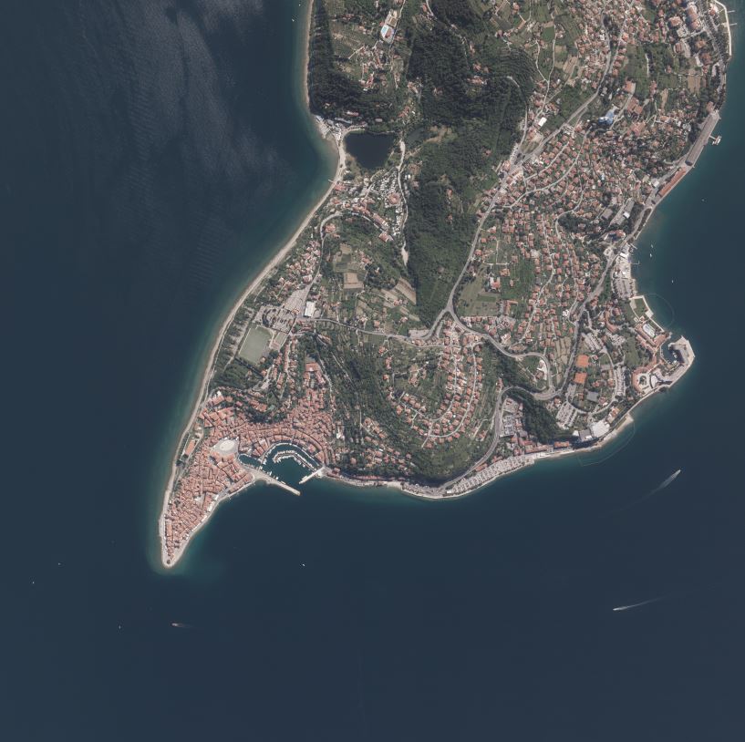
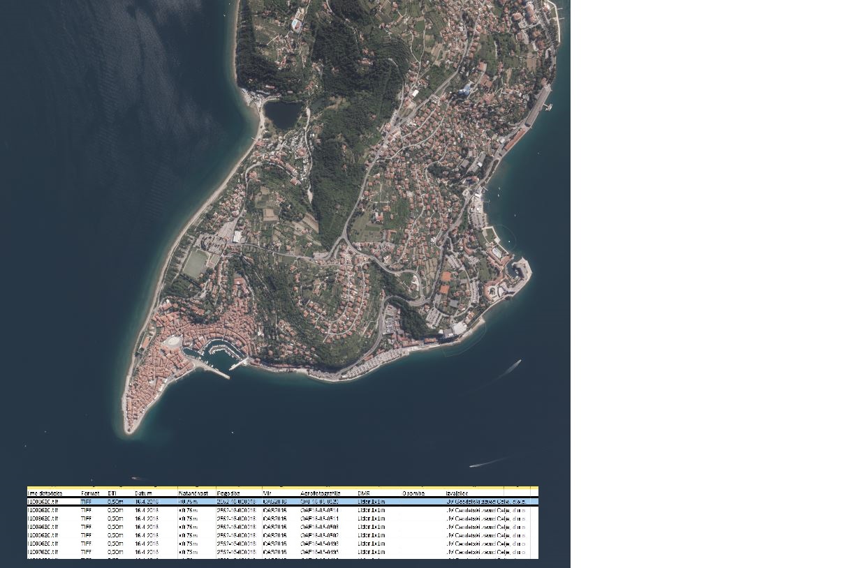
Product of aerial survey (from airplane, helicopter) are aerial images as well as external orientation elements, that are used as final product or as an input parameter for further image processing. In the cyclical aerial survey of Slovenia professional (recently digital, large format) aerial cameras are used. These cameras use simultaneous surveying of aerial photos in several channels (panchromatic, red, green, blue, near infrared). Usuall ground sampling distance (GSD) is 0.25 m.
-
Baza pokrovnosti tal CLC 2006 je narejena iz kombinacije baze CLC 2000 in baze sprememb v pokrovnosti tal med letoma 2000 in 2006. Baza sprememb je bila narejena s pomočjo vizualne interpretacije satelitskih posnetkov. V primeru odkrite napake v bazi CLC 2000 se je popravila tudi ta baza. Rezultat tega je popravljena baza CLC 2000. Podatki so namenjeni za vsedržavno podatkovno bazo rabe in pokrovnosti tal, ki je primerljiva z ostalimi državami v Evropi. Primeri uporabe v Sloveniji: - za poročanje Evropski agenciji za okolje: o vodah, pozidavi in prekrivanju tal, o stanju morja in obale, Evropski komisiji: pri interkalibracijski vaji merilnih mest na površinskih vodotokih, - za posodobitev mreže monitoringa kakovosti podzemnih voda, - kot podlaga za izvajanje monitoringa tal, - kot indikator pokrovnosti, - kot osnovni sloj projekta Inspire, - kot podlaga pri projektu Nopolu, - kot podlaga za Naturo 2000. Primeri uporabe v Evropi: - modeliranje onesnaženosti tal v črnem trikotniku na nemško-češko-poljski tromeji - ugotavljanje nevarnosti erozije prsti na Slovaškem, - modeliranje koncentracije fosforja v rekah na Slovaškem, Madžarskem in v Romuniji, - razmejitev manj ugodnih kmetijskih površin na Poljskem, - izdelava turistične karte Slovaške, - ugotavljanje sprememb rabe pokrajine na Slovaškem. Področja uporabe CLC v Evropi: - prostorske analize, - vrednotenje in ocenjevanje podatkov o pokrovnosti, rabi tal in kakovosti zemljišč, - prikaz sprememb, - analiza pokrajin, - pokrajinski indikatorji, - analiza vodotokov in rabe mokrišč, - razvoj GIS za potrebe NATURA 2000 - ugotavljanje sprememb za potrebe določanja habitatov in ocen izpostavljenosti ranljivih območij, - ocena CO2 emisij, - podatki o pokrovnosti okrog merilnih postaj, - nova dodelitev parametrov kakovosti zraka glede na podatke o pokrovnosti, - vpliv transporta, odvzem zemljišč za potrebe prometa, - vpliv na zavarovana območja.
-
Vector data collection DPK 750V is an object-oriented cartographic database at 1 : 750 000 scale. Elements on the map are divided into eight object groups: mathematical elements, settlements and objects, communications, relief, hydrography, land cover, boundaries and dividing line, geographical names. The data set is used for "rough" geo-orientation and for the needs of large scale and thematic displaying.
-
Vector data collection DPK 500V is an object-oriented cartographic database at 1: 500 000 scale. Elements on the map are divided into eight object groups: mathematical elements, settlements and objects, communications, relief, hydrography, land cover, boundaries and dividing line, geographical names. The data set is used for "rough" geo-orientation and for the needs of large scale and thematic displaying.
-
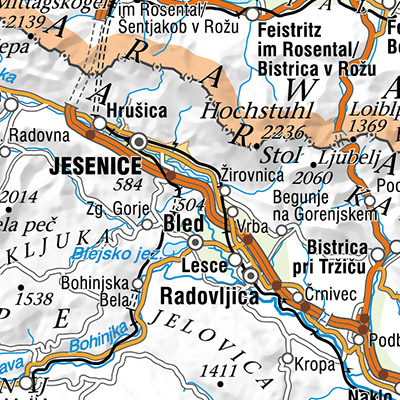
The National General Map at 1 : 750 000 Scale shows the entire territory of Slovenia on one sheet of A3 format. Layers: mathematical elements, settlements and objects, communications, relief, hydrography, land cover, boundaries and dividing line, geographical names. The data set is used for "rough" orientation in the space and for the needs of large scale and thematic displaying.
-
Vektorska zbirka podatkov DPK 2500V je objektno orientirana kartografska zbirka podatkov merila 1 : 1 000 000. Objekti so razdeljeni v petobjektnih skupin: naselja in objekti, komunikacije, hidrografija, meje in ločnice, zemljepisna imena. Podatkovni niz se uporablja za "grobo" orientacijo v prostoru, za potrebe preglednih in tematskih prikazov.
-
The vector data collection DPK 1000V is an object-oriented cartographic database at 1 : 1 000 000 scale. Elements on the map are divided into eight objects groups: mathematical elements, settlements and objects, communications, relief, hydrography, land cover, boundaries and dividing line, geographical names. The data set is used for "rough" orientation in the space and for the needs of large scale and thematic displaying.
-
The vector collection of data DPK 250V is object oriented cartographic database at 1 : 250 000 scale. Elements on the map are divided into eight groups: mathematical elements, settlements and objects, communications, relief, hydrography, land cover, boundaries and dividing lines, geographical names.